


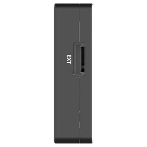
Makerfire UTMSYS USR20-A Positioning/Orientation RTK Module Sky Side
USR20-A Positioning/Orientation RTK Module Sky Side – High-Precision GNSS RTK for UAVs
The USR20-A Positioning/Orientation RTK Module Sky Side is a state-of-the-art airborne navigation system designed to provide centimeter-level precision and real-time heading calculation for Unmanned Aerial Vehicles (UAVs). Equipped with dual antennas and multi-frequency GNSS signal reception, this RTK module supports global satellite constellations, including GPS, GLONASS, Galileo, QZSS, and BDS, ensuring accurate and reliable positioning data for various flight operations.
This advanced RTK module replaces traditional magnetic compasses, offering a 3-axis electronic compass that resists electromagnetic interference, making it ideal for complex flight environments. Whether you're involved in surveying, inspection, or security operations, the USR20-A module guarantees stable flight path tracking, high-precision hovering, and orientation accuracy—even in challenging conditions.
With an integrated design, this module supports high-speed data output, differential data link interactions, and is optimized for UAV systems requiring robust positioning and heading capabilities. Whether you're performing detailed inspections or flying autonomous missions, the USR20-A ensures high operational reliability and precise flight control at all times.
Key Features:
- Centimeter-level RTK positioning for precise navigation
- Dual antennas for real-time heading and orientation calculations
- Supports global multi-frequency GNSS constellations: GPS, GLONASS, Galileo, QZSS, BDS
- Electronic 3-axis compass for stable and reliable heading data
- Resists electromagnetic interference for enhanced flight stability
- Fast first location time: Cool start ≤ 30s, Hot start ≤ 5s
- RTK measurement time ≤ 5 minutes for high-accuracy positioning
- Data update rate of 20Hz for real-time navigation
- Integrated design with strong adaptability and minimal installation complexity
- Ideal for surveying, inspection, security, and autonomous UAV operations
Technical Specifications:
- Working Voltage: 12V
- Working Current: 350mA
- Electronic Compass: 3-Axis
-
GNSS Navigation System:
- BDS B1I/B2I/B3I
- GPS L1C/A/L2P (Y)/L2C/L5
- GLONASS L1/L2
- Galileo E1/E5a/E5b
- QZSS L1/L2/L5
- Antenna Gain: 2.5 dBi
- LAN Gain: 33±2dB
- First Location Time: Cool start ≤ 30s, Hot start ≤ 5s
- RTK Measurement Time: ≤ 5 minutes @ 2.0m CEP
- Data Update Rate: 20Hz
- Size: 52mm x 34.8mm x 14.5mm
- Weight: 30g
- Operating Temperature: -20°C to 60°C
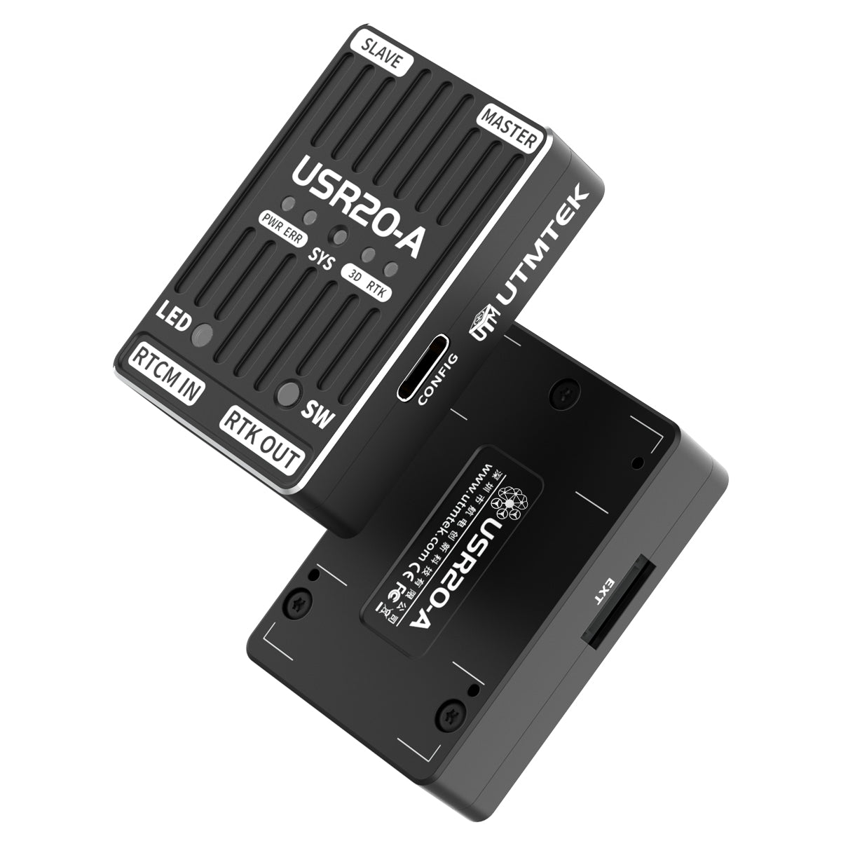
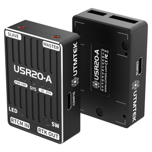
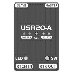
Interfaces:
- CONFIG: Configuration interface, Type-C
- RTCM IN: Differential signal input interface, GH1.25-6P
- RTK OUT: Flight controller GPS1 interface, GH1.25-10P
- MASTER: Main antenna interface (positioning), MMCX
- SLAVE: Secondary antenna interface (assisting in direction finding), MMCX
- SW: Safety button
- LED: Colored lights
- SYS: Flight control indicator lights
- PWR: RTK power LED
- ERR: RTK error LED
- 3D: RTK 3D positioning mode indicator
- RTK: RTK FIX mode indicator
Description
USR20-A Positioning/Orientation RTK Module Sky Side – High-Precision GNSS RTK for UAVs
The USR20-A Positioning/Orientation RTK Module Sky Side is a state-of-the-art airborne navigation system designed to provide centimeter-level precision and real-time heading calculation for Unmanned Aerial Vehicles (UAVs). Equipped with dual antennas and multi-frequency GNSS signal reception, this RTK module supports global satellite constellations, including GPS, GLONASS, Galileo, QZSS, and BDS, ensuring accurate and reliable positioning data for various flight operations.
This advanced RTK module replaces traditional magnetic compasses, offering a 3-axis electronic compass that resists electromagnetic interference, making it ideal for complex flight environments. Whether you're involved in surveying, inspection, or security operations, the USR20-A module guarantees stable flight path tracking, high-precision hovering, and orientation accuracy—even in challenging conditions.
With an integrated design, this module supports high-speed data output, differential data link interactions, and is optimized for UAV systems requiring robust positioning and heading capabilities. Whether you're performing detailed inspections or flying autonomous missions, the USR20-A ensures high operational reliability and precise flight control at all times.
Key Features:
- Centimeter-level RTK positioning for precise navigation
- Dual antennas for real-time heading and orientation calculations
- Supports global multi-frequency GNSS constellations: GPS, GLONASS, Galileo, QZSS, BDS
- Electronic 3-axis compass for stable and reliable heading data
- Resists electromagnetic interference for enhanced flight stability
- Fast first location time: Cool start ≤ 30s, Hot start ≤ 5s
- RTK measurement time ≤ 5 minutes for high-accuracy positioning
- Data update rate of 20Hz for real-time navigation
- Integrated design with strong adaptability and minimal installation complexity
- Ideal for surveying, inspection, security, and autonomous UAV operations
Technical Specifications:
- Working Voltage: 12V
- Working Current: 350mA
- Electronic Compass: 3-Axis
-
GNSS Navigation System:
- BDS B1I/B2I/B3I
- GPS L1C/A/L2P (Y)/L2C/L5
- GLONASS L1/L2
- Galileo E1/E5a/E5b
- QZSS L1/L2/L5
- Antenna Gain: 2.5 dBi
- LAN Gain: 33±2dB
- First Location Time: Cool start ≤ 30s, Hot start ≤ 5s
- RTK Measurement Time: ≤ 5 minutes @ 2.0m CEP
- Data Update Rate: 20Hz
- Size: 52mm x 34.8mm x 14.5mm
- Weight: 30g
- Operating Temperature: -20°C to 60°C
Interfaces:
- CONFIG: Configuration interface, Type-C
- RTCM IN: Differential signal input interface, GH1.25-6P
- RTK OUT: Flight controller GPS1 interface, GH1.25-10P
- MASTER: Main antenna interface (positioning), MMCX
- SLAVE: Secondary antenna interface (assisting in direction finding), MMCX
- SW: Safety button
- LED: Colored lights
- SYS: Flight control indicator lights
- PWR: RTK power LED
- ERR: RTK error LED
- 3D: RTK 3D positioning mode indicator
- RTK: RTK FIX mode indicator